Skip to main content
English
Español
Français
United
Nations
Office for Outer Space Affairs
UN-SPIDER Knowledge Portal
Rechercher
Accueil
À propos
Qu'est-ce que l'ONU-SPIDER?
À propos d’UNOOSA
Publications
Offres d'emploi
Rencontrez l'équipe
Contact
Applications spatiales
Technologie satellitaire
Mécanismes d’urgence
Recovery Mechanisms
Réseau international d'alerte aux astéroïdes
Space Mission Planning Advisory Group
Initiative internationale sur la météorologie spatiale
Les technologies spatiales à l'ONU
Comptes-rendus d'utilisateurs
Liens & ressources
Application de données du mois
Disaster Recovery
Sources de données
SIG et logiciels de télédétection
Online Learning Resources
Institutions
Risques & catastrophes
Prévention des risques de catastrophe
Systèmes d'alerte précoce
Gestion des catastrophes et des interventions d'urgence
Aléas naturels
Cadre d'action de Sendai
L'ONU et la prévention des risques de catastrophe
L'ONU et les alertes précoces
L'ONU et la gestion des catastrophes
Appui technique
Missions Conseil
Appui d’urgence
Appui à distance
Pratiques recommandées
Activités de formation
Utilisations pratiques
Réseaux
Bureaux régionaux d’appui
GP-STAR
MHEWS
IWG-SEM
Projets
SPEAR
SEWS-D
EvIDENz
Flood GUIDE
Actualités
Actualités
Événements
Événements passés
Breadcrumb
Home
Locust Watch (DLIS - FAO)
Locust Watch (DLIS - FAO)
Locust Watch (DLIS - FAO)
Data provided by:
Food and Agriculture Organization of the United Nations (FAO)
Data accessibility:
export map
Link to the data:
Latest Desert Locust Bulletin
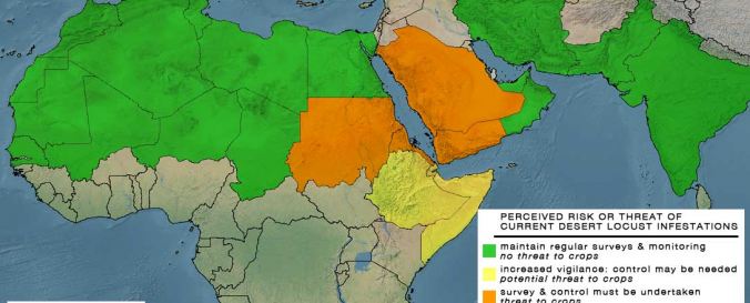
Desert Locust risk maps
Desert Locust outbreaks
Current threats
File type:
jpeg
,
jpeg
,
txt
Data type:
hazard specific data
Hazard:
Insect Infestation
Disaster cycle phase:
Disaster Risk Management, Response, Recovery
Satellites and Sensors:
Aqua
,
Terra
,
NOAA-15
,
SPOT 4
,
Meteosat-8 (SEVIRI)
Spatial coverage:
Algeria, Chad, Eritrea, India, Mauritania, Pakistan, Saudi Arabia, Sudan, Yemen
Spatial resolution:
250.00
Temporal coverage:
Archive, Near-real time
Content dates:
2000-present
Technical Specifications:
Satellite Information for Locust Forecasting
Costs:
free
Contact:
Contact National Locust Directors and Information Officers
Tutorials on the use of data:
Technical Note for Desert Locust product
Restrictions/ Citation of the dataset:
Publications
Provider